Winter storm warning issued to begin Monday
The National Weather Service has upgraded the winter storm watch to a warning from 7 a.m. Monday to 4 p.m. Wednesday.
Heavy snow and blowing snow is expected. Total snow accumulations are likely to be around 10 to 20 inches. Winds could be gusting as high as 50 mph, creating blowing and drifting snow and at times white out conditions.
Greatest snow accumulation across the northern Chautauqua Ridge, Boston Hills and Buffalo Southtowns.
Whiteout conditions are expected and will make travel treacherous and potentially life-threatening. Travel will be very difficult in deep snow covered roads. Areas of blowing snow will significantly reduce visibility. The hazardous conditions will impact the Monday evening through the Wednesday morning commutes.
Gusty winds will down tree branches and cause isolated power outages.
Expect lake snow band to oscillate with varying intensities and snowfall amounts over the area. Snowfall rates 2 inches per hour Monday afternoon through Tuesday morning.
Wind chill values will be five to 15 below zero Monday night through Tuesday night.
Latest news
Winter storm warning issued to begin Monday
The National Weather Service has upgraded the winter storm watch to a warning from 7 a.m. Monday to 4 p.m. ...

Crashes impact traffic on state Thruway near Angola exit
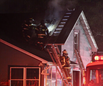
Townsend St. home damaged in city fire

UPDATE: Police charge city school employee with child endangerment
Motorist charged with DWI after striking vehicle, leaving scene in city
A 25-year-old man is facing a number of charges after striking a car that then hit a house on Saturday ...
Man dies in car-pedestrian accident in Jamestown
A Jamestown resident died Saturday after a car-pedestrian accident on Falconer Street near Bowen Street. Jamestown ...