
A new tool for hunters
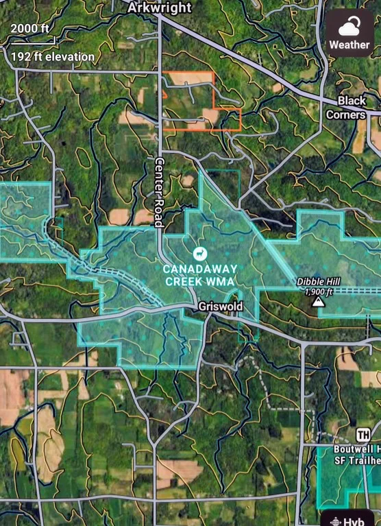
Photo courtesy of Forrest Fisher New software from OnX Hunt allows users to navigate private and public land boundaries, 3-D satellite and topographic base maps, offline maps, and hunt-specific layers such as woodland tree types, public access areas, complete with landowner tax-payer name identification.
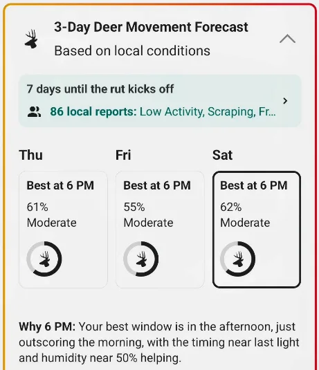
Photo courtesy of Forrest Fisher The magic of the whitetail rut is engineered around daylight, weather factors, moon phase and overall herd health. This program provides accurate details for each hunting zone.
Photo courtesy of Forrest Fisher New software from OnX Hunt allows users to navigate private and public land boundaries, 3-D satellite and topographic base maps, offline maps, and hunt-specific layers such as woodland tree types, public access areas, complete with landowner tax-payer name identification.
Photo courtesy of Forrest Fisher The magic of the whitetail rut is engineered around daylight, weather factors, moon phase and overall herd health. This program provides accurate details for each hunting zone.
Trending
For hunters in Chautauqua County and across southwest New York, knowing where you stand -- and where you can legally hunt -- is every bit as important as knowing when the deer are moving. A smartphone app called onX Hunt offers a useful way to put that information right in your pocket.
I met Jack Flatley this week at the Association of Great Lakes Outdoor Writers Conference, a young outdoorsman who helped to explain a new software program application for a cellphone that we hunters can use wherever we hunt. I found his help and this program to be priceless.
Available for both Apple and Android phones, onX Hunt combines detailed mapping with property boundaries, land ownership information, public-land access, trails, and a variety of tools designed with hunters in mind. I like that you don’t have to ask, "I wonder who owns that land right next to the state forest?"
One of its biggest advantages is the ability to identify public lands, including state forests and other public properties, while viewing private parcel boundaries and providing public domain ownership information. For local hunters exploring unfamiliar ground, this can help identify potential hunting locations, understand property lines, and determine where permission may be needed. Maps also display Wildlife Management Units, making it easier to identify the unit you’re hunting in and review relevant regulations, including who to ask for landowner permission.
The app offers several map views, including topographic and 3-D maps, so hunters can better understand hills, valleys, terrain, and access routes. You can mark promising locations with custom waypoints, measure distances, calculate acreage, and record your route and elevation profile. Live tracking and location-sharing features can also help hunting partners stay connected in the field.
Perhaps one of the most valuable features is offline mapping. Users can download detailed maps before leaving home and access them in areas without cell service. In rural parts of Chautauqua County and beyond, that can be a real advantage. Just remember that GPS location and downloaded maps do not replace a compass, a backup navigation plan, or basic outdoor safety practices.
Weather is another important consideration. The onX Hunt app includes forecasts and hunting-related weather information, including wind and barometric pressure data for specific pinpoint locations. These details can help us hunters evaluate conditions and plan the best time outdoors. As with any forecast, local conditions can change, but this program sorts out the riffles before heading out.
Wondering when the deer rut will start in 2026? One easy answer is that it will land when it happens because the whitetail rut is engineered around daylight, weather factors, moon phase, and overall herd health. Together, these things influence when and how heavily deer are on the move during peak times. The core peak breeding window in each locale, however, is something you can plan around right now, weeks before the first cold front with this software. The map and information layers available are impressive.
The subscription cost is another attraction. At the advertised price of $35 annually for New York state coverage, it is an affordable tool for hunters who regularly explore new properties or want a better understanding of the land around them. Subscription prices, included features, and renewal terms should be confirmed before signing up. For all 50 states, the cost is $100 per year, worth it if you're heading west for elk or antelope. For either subscription, there is onX SOS that connects you to the 24/7 professional rescue team at Overwatch x Rescue, who coordinate emergency support and cover rescue and evacuation costs. No claims process. No surprise bills. Just help when you need it most, from a real person on the other end. Imagine needing an emergency helicopter transfer from your hunting zone and receiving a $50,000 bill?
No app replaces good judgment, permission from landowners, or a thorough understanding of hunting regulations. Remember too that property records can also contain errors or lag behind recent ownership changes, so boundaries and access rights deserve careful verification. Go ask permission face to face and smile.
My summary after exploring this program for hunters looking to discover new hunting spots, including the hot wildlife trails formed because of white oak tree stands -- this program identifies those areas within 20-by-20 foot quadrants. Also provides other similar land attractions for deer opportunities with map layers. The bottom line is that you can navigate unfamiliar terrain, learn more about land you already hunt, and make better-informed decisions. I have it now, onX Hunt will change the way I think to become a better hunter, a more successful hunter. Knowing the land is the first step toward a more enjoyable and responsible day afield.
Gotta love the outdoors.
CALENDAR
Oct. 17: Women Fishing Class; 3-4:30 p.m., The Hairy Trout, 3891 Seneca St., West Seneca, w/Nicole Marie and Sara Hastings.
Oct. 17-30: Fall turkey hunting season, one bird either sex allowed, sunrise to sunset. See dec.ny.gov for zones.
Oct. 18: Firearm Sighting-In Day, Bear Lake Rod & Gun Club, handguns 10 a.m., rifles/shotguns, noon. Paper targets at 50, 100, 150 and 200 yards. Info: Don Campbell, 716-338-2050.
Oct. 20: Children in the Stream Youth Fly Fishing/4-H Program, Fly tying/fly fishing classes, 7-8:30 p.m., free, Costello Room, Rockefeller Art Center at SUNY Fredonia, For info: email Alberto@albertorey.com.
Oct. 21: Fly Tying Class, 6-8 p.m., free, Falconer Rod & Gun Club, 329 Falconer St., Jamestown; info: 716-467-0782.